View PDF
| Canmore ID |
274203 |
SCRAP ID |
1064 |
| Location OS Grid Ref: |
NN 54123 35389
|
Team |
Not in team
|
|
Existing Classifications
|
| Classification |
Period |
| CUP MARKED ROCK |
PREHISTORIC |
|
| Date Fieldwork Started |
18/05/2021 |
Date Fieldwork Completed |
|
| New Panel? |
No |
|
A1. Identifiers
| Panel Name |
FALLS OF LOCHAY |
Number |
1 |
| Other names |
|
| HER/SMR |
|
SM Number |
|
Other |
|
Classifications And Periods
| Classification 1 |
Cup And Ring Marked Rock |
Period 1 |
Neol/bronze Age |
County
STIRLINGSHIRE
A2. Grid Reference(original find site)
| OS NGR |
NN |
54015 |
35236 |
| New OS NGR |
NN |
54123 |
35389 |
| Lat/Long |
56.48792 |
-4.3707 |
| Obtained By: |
Google Earth
|
A3. Current Location & Provenance
| Located |
|
| Accession no. |
Not given |
B1. Landscape Context
| Weather |
Sunny Intervals
|
| Position in landscape |
Hillside |
| Topography(terrain within about 500m of panel.) |
Sloping |
| Aspect of slope (if on sloping terrain e.g. S, SE etc.) |
S |
B2. Current land use & vegetation
B3. Forestry
B4. Archaeological Features within 200m / or visible from the panel
- Other rock art
- Field System
B5. Location Notes
The panel is the northern of two panels (with Falls of Lochay 2, ScRAP 1933) on a large outcrop of Schist bedrock at about 217m asl, on the N side of Glen Lochay, 350m NW of the Falls of Lochay. Overall the outcrop measures 6m N-S by up to 3.5m E-W, and slopes to the S at an average of 25 degrees. This and other exposures of bedrock to the E and W form a distinct ridge on the lower S slope of Creag Dhuin Croisg. The top of the outcrop is 2m S of an overgrown bank, the ground dipping slightly to its N; to the S of the panel, the ground slopes moderately steeply to the S for 8m, then drops more steeply. This panel lies 2m S of the bank. There is a smaller exposure of bedrock 4m to the W. The view to the S is across the glen to the hills to the S; to the E, down the glen, it is obscured by trees and nearby rising ground; to the N it is up Creag Dhuin Croisg; and to the W there is an extensive view up the glen, with the outcrop bearing the panels at Duncroisk Lower 1-9 (ScRAP 3409-3417), 1km to the WNW, clearly visible. There are further rock art panels broadly distributed along the floor and sides of the glen, but the only other recorded within 200m is Falls of Lochay 2, (ScRAP 1933), 1m to the S on the same outcrop as this panel. The only other visible feature is the old boundary bank to the immediate N, which appears to be the head dyke on the 1st edition OS map 1867. Falls of Lochay 1 and 2 were previously grouped together in the same Canmore record (Canmore 274203).
Previous Notes
NN53NW 41
NN 54015 35236 Ledge, 1m above ground level on a rock face; four cups, 50 x 25mm, 45 x 15mm and two at 40 x 10mm.
NN 54123 35381 Outcrop on lower slopes of Meall Dhuin Croisg, 0.3km NNE of Falls of Lochay (1). Section 1 has eight cups: two at 50 x 10mm, two at 55 x 10mm, 50 x 10mm and one shallow cup. Section 2, 1m to the S, has two cups, 40 x 10mm, and three shallow.
G Currie 2004
C1. Panel Type
C2. Panel Dimensions, Slope & Orientation
Dimensions of panel (m to one decimal place)
| Length (longer axis) |
2.6 |
Width |
1.1 |
| Height (max) |
0.1 |
Height (min) |
0 |
Approximate slope of carved surface
Orientation (Aspect e.g. NW)
| Rock Surface |
W |
Carved Surface |
W |
Carved Surface |
|
C3. Rock Surface
| Surface Compactness |
Hard
|
Grain Size |
Coarse
|
Visible Anomalies |
Quartz Veins
Nodules
Colour Bands
|
Rock Type |
Schist
|
C4. Surface Features
- Fissures/cracks
- Natural Hollows
- Bedding Planes
- Weathering Channels
- Rough surface
C5. Panel Notes
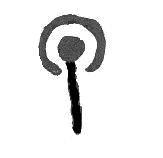
The panel forms the highest part of a large Schist outcrop that slopes down to the S, and which includes relatively smooth surfaces separated by wide eroded fissures. It measures 2.6m (E-W) x 1.1m, and is up to 0.1m high. Its S edge is defined by a prominent fissure, and a quartz band which curves to the NE at the E, as well as a large stone inclusion at the W. It is widest in its E half, which forms a relatively flat surface sloping slightly to the W, and which bears all the certain motifs; the panel narrows to the W. The Schist is hard and coarse grained, although flaking at the bedding plains and fissures. There are localised areas of iron staining. The decoration comprises a group of 13 plain cupmarks with no apparent pattern, and 1 cupmark with a W pointing radial line surrounded by a 100mm diameter open ring on the W edge of the group. The cupmarks measure 30mm-60mm in diameter, and are no more than 10mm deep. Only 9 of them were identified during initial recording, and the panel was revisited to investigate features, including the ring, indicated by the 3D modelling. Many of the cupmarks are small and very shallow, and in addition to the 13 identified, there are at least 4 other possible marks, all but one in the main group; the other lies to the W. The distinction between certain cupmarks, possible cupmarks, and slight, probably natural depressions is a fine one.
C6. Probability
The probability that there is any rock art on the panel is
Definite
Comments
No comments added
C7. MOTIFS
Cupmark

|
|
13
|
Cup and Rings
|
|
1
|
Visible Tool Marks? No
Visible Peck Marks? No
D1. Access
D2. Awareness
- Panel was known before the project.
- This panel is known to others in the local community.
There are stories or folk traditions associated with this panel No
D3. Risk
Natural
Animal
Human
Comments and other potential threats
No sheep were noted, but the fencing to the S suggests the area is grazed